TL;DR
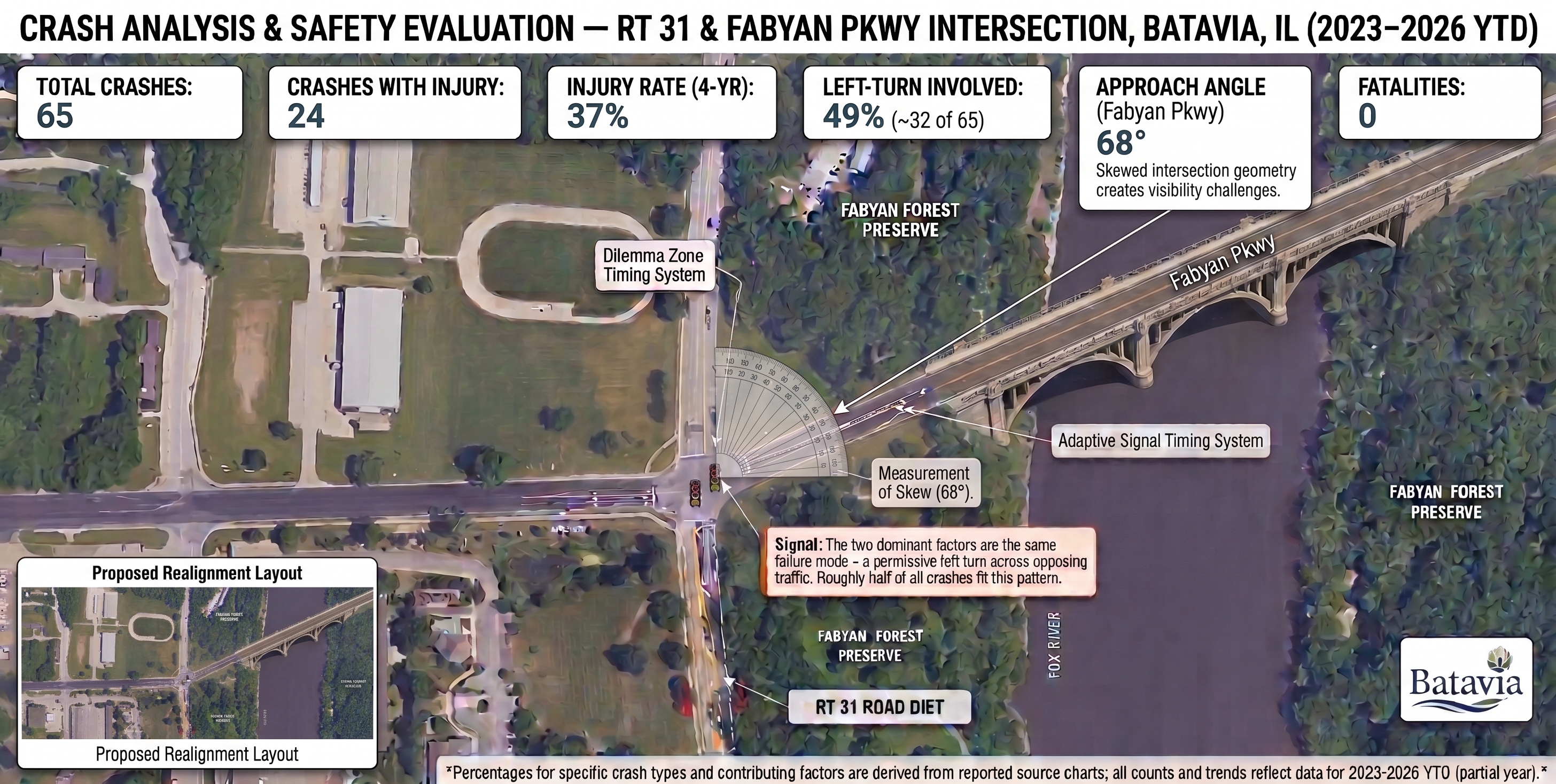
A recent review of Batavia Police Department traffic data from early 2023 through August 2026 reveals that the intersection of West Fabyan Parkway and Route 31 remains a significant hazard, averaging 18 crashes per year. The primary danger stems from vehicles making left-hand turns, which account for nearly half (49%) of all collisions and a staggering 67% of all injury-causing accidents at the site. These crashes, primarily caused by drivers failing to yield the right-of-way, are directly tied to the intersection’s severe 68-degree skewed geometry that creates massive blind spots. To combat this, local officials have implemented short-term measures like smart radar sensors and a recent Route 31 “road diet,” while Kane County is actively planning a complete structural realignment to permanently fix the dangerous angle and improve overall traffic safety.
Recently, we had another accident at the intersection of Fabyan and 31, and while more structural improvements are in motion, it’ll likely take years (if not decades) before they’re implemented. In the meantime, the police have released a more “finely tuned” analysis of the recent crashes highlighting the frequency of accidents involving people trying to make a left turn across traffic.
A Consistent Crash Hotspot
Between early 2023 and late August 2026, the intersection saw 65 total crashes, holding steady at an average of about 18 collisions per year.

How does this compare to the rest of Batavia?
While Fabyan and Route 31 is notoriously tricky, the Randall Road corridor remains the city’s highest-volume crash zone. A recent 2026 Batavia Police study found over 760 crashes along Randall Road since 2019. Intersections like Randall and Mill Street, Randall and McKee Street, and Randall and Wilson Street have seen major left-turn, failure-to-yield collisions recently, including two tragic fatal crashes in early 2026 that prompted a dedicated city safety assessment.
Thankfully, Fabyan and Route 31 did not record any fatal injuries during the 2023-2026 window. However, its unique physical layout makes the risk of severe injury dangerously high.
The Left-Turn Dilemma and Failing to Yield
When we look closer at the numbers, one specific maneuver stands out as the main culprit: turning left. In 49% of all crashes at this intersection, the at-fault driver was attempting a left-hand turn.
Tied directly to those tricky left turns, failure to yield the right-of-way was logged as the primary or secondary cause for 46% of the collisions.

Injuries Linked to Left Turns
Even without fatalities, the risk of getting hurt here is significant. Out of the 65 total crashes, 24 resulted in injuries to vehicle occupants.
Left turns are disproportionately to blame, as 67% of those injury crashes were caused by a driver executing a left turn. Police data suggests a direct correlation between at-fault drivers turning left and a higher incidence of injury:
- Three crashes during this multi-year period resulted in suspected serious injuries. Two of those serious accidents involved a left-hand turn, while one was the result of a vehicle skidding or losing control.
- What’s most concerning for local drivers is that 2026 has already tallied six left-turn-related injury crashes—the highest concentration in the studied timeline.

Why Is This Intersection So Dangerous?
The root of the problem isn’t just driver error; it’s the physical geometry of the road. While the western leg of Fabyan Parkway meets Route 31 almost straight on, the eastern leg connects at a severe, 68-degree skewed angle.
This awkward alignment creates massive blind spots for drivers waiting in the intersection to turn left. Judging the speed and distance of oncoming traffic becomes a dangerous guessing game. The community knows this well, particularly following a tragic 2015 fatal crash where a left-turning vehicle collided with an oncoming van.

What Are the City and County Doing About It?
Local and county leaders are well aware of the danger and have been actively implementing safety measures while long-term solutions are designed:
- Smart Sensors: In late 2022, the Kane County Division of Transportation (KDOT) installed advanced radar sensors and warning flashers. This technology monitors the speed of approaching vehicles and adjusts the signal timing to create safer traffic gaps, helping drivers avoid split-second braking decisions.
- The Route 31 “Road Diet”: In the fall of 2024, Batavia and the state narrowed Route 31 down to Mooseheart Road, converting four lanes into three with a dedicated center turn lane. This gave turning vehicles a safe refuge space, reducing the volume of rear-end crashes.
- Permanent Realignment: KDOT is planning a massive structural redesign to fix the intersection’s dangerous 68-degree skew. In May 2026, the county presented concrete layout options to the public, marking a major step toward permanently correcting the intersection’s blind spots and improving safety for everyone who relies on this crucial river crossing.
Author: Jim Fahrenbach

Leave a Reply